2012: Oskar Hansen’s Precession Design of Mayan Star Map – Hoover Dam Part II
Interesting 2012 stuff! Isn’t it? In this blog, our Director, Lord Pakal Ahau, completes his research paper of Oskar Hansen’s design of a celestial Mayan star map for the Hoover Dam. If you got here browsing the search engines, we recommend you start from the beginning of Part I.
GENERAL CONSIDERATIONS
Oskar J. W. Hansen was a very unique and special man. Besides his military service in the US where he rose from a Private to Major of the US Army, he was esoteric, almost dealing with the occult, but very spiritual and his ‘near-death experience’ changed his philosophy of life.
From one of his speeches in 1928 that reminds me of the Maya language development, he expressed, “Man has always sought to express and preserve the magnitude of his exploits in symbols. The written words are symbols arranged so as to preserve in objectified form the thought of man and to record his variant states, both mental and physical. All other arts are similar as to their symbolic significance. They take their place among the category of human endeavor simply as the interpreter of life to itself. They serve as an outer object typifying the inner process. They form the connecting link between the spiritual and the material world. They are the shadows cast by the realities of the soul.”
Hoover Dam is located in the borders of Nevada and Arizona with geographical coordinates (GPS) 36° 01′ .6222 North and -114° 73′.7245 West.
GENERAL LAYOUT DESIGN FEATURES
In the general design you will find three main features that are not interconnected, but they have a meaningful aspect to the Hoover Dam construction: the Memorial Plaque, the Winged Figures of the Republic, and the Celestial Star Map.
In 2001, I made a preliminary sketch of the layout, however, that one did not present the whole layout. So, I decided to revise the diagram to show the whole design. Below, you will find the complete diagram with alphabetical sections so you can follow it in more detail.
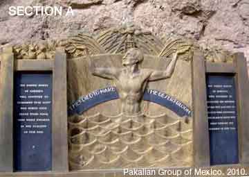
Section A describes the Memorial inscriptions. The Memorial is set into the rock canyon wall and pays tribute to workman labor. The inscriptions read: “They died to make the desert bloom. The United States of America will continue to remember that many who toiled here found their final rest while engaged in the building of this dam. The United States of America will continue to remember the services of all who labored to clothe with substance the plans of those who first visioned the building of this dam”.
The above inscriptions commemorate the 96 workers who officially died during the construction of Hover Dam.
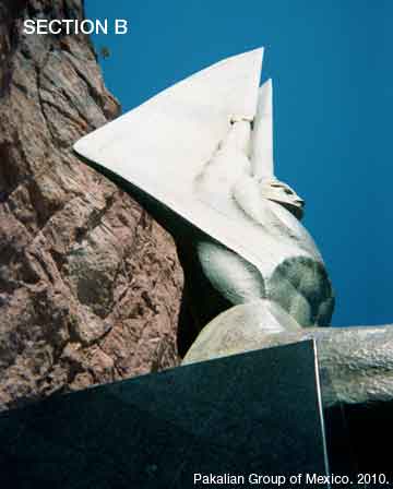
Section B shows Hansen’s sculptures known as the Winged Figures of the Republic, placed on either side of the 142-feet flag pole. The castings are 30 feet high. Their shells are 5/8-inch thick and contain more than four tons of statuary bronze. The figures were formed from sand molds weighing 492 tons. The bronze that forms the shells was heated to 2,500 degrees Fahrenheit, and poured into the molds in one continuous, molten stream.
The figures rest on a base of black diorite, an igneous rock. In order to place the blocks without marring their highly polished finish, they were centered on blocks of ice, and guided precisely into place as the ice melted. After the blocks were in place, the flagpole was dropped through a hole in the center block into a pre-drilled hole in the mountain.
As symbols they express, according to the sculptor, the immutable calm of intellectual resolution, and the enormous power of trained physical strength, equally enthroned in placid triumph of scientific accomplishment.
Let us now concentrate in the main feature of Hansen’s design. The celestial Star Chart.
CELESTIAL STAR CHART FOR HOOVER DAM
Surrounding the base is a terrazzo floor, inlaid with a star chart, or celestial map. The chart preserves for future generations the date on which President Franklin D. Roosevelt dedicated Hoover Dam, September 30, 1935.
Important stars and features of the Polar region of the sky are shown as it appeared at 8:56pm 2.25 secs local apparent time on September 30, 1935 when this structure was dedicated.
The apparent magnitudes of stars on the chart are shown as they would appear to the naked eye at a distance of about 190 trillion miles from earth (10 parsecs from our Earth). It required 3 1/4 sidereal years to travel a distance of one parsec at a rate of 186,300 miles per second. In other words, one parsec represents approximately 19 trillion miles. The actual distance to most of the stars is more than 50 parsecs. In reality, the distance to most of the stars is more than 950 trillion miles.
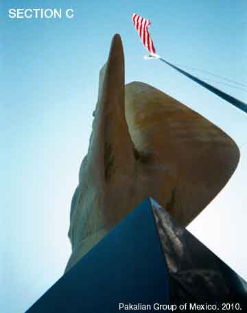
Section C of my diagram is the 142-feet flag pole. On this star map, the center of the Sun is shown as the very center of the flag pole. The positions of the stars included in the map are then related in hour, minutes, and right ascension from this center of the Ecliptic.
The true obliquity of the North Pole of the Earth’s Equator is shown in the same manner. All information related to astronomical theories was verified by the US Naval Observatory, the Smithsonian Institution and other reliable sources.
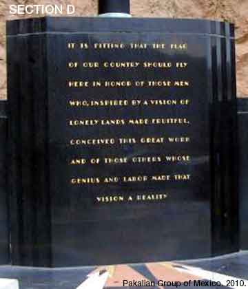
Section D is the flag pole inscription and recognizes those who envisioned and built Hoover Dam. It reads, “It is fitting that the flag of our country should fly here in honor of those men who, inspired by a vision of lonely lands made fruitful conceived this great work and of those other whose genius and labor made that vision a reality.”
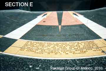
Section E explains a complete sidereal revolution of the Equinox. It reads, this diagram traces a complete sidereal revolution of the Equinox, otherwise known as the Platonic or Great Year. The average length of a complete sidereal revolution is 25,694.8 tropical years; but may differ from the mean time of revolution by 281.2 years the mean line of the precession of the role of the Earth’s equator shown here by the outside circumference on this white metal circle. It’s 46.9 degrees in diameter.
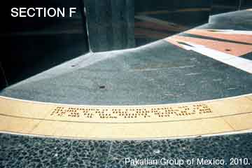
Section F explains the inclination of the Earth’s equator. It reads, the inclination of the Earth’s equator may vary relative to the fixed ecliptic, from 21 deg 59 min to 24 deg 36 min and her role therefore nutates in a zone 2 deg 37 min as shown here by this yellow band.
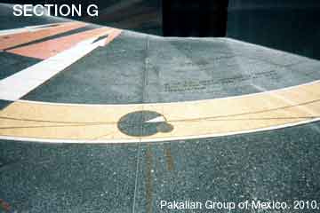
Section G shows the Right Ascension of the Meridian. Right ascension is the celestial equivalent of terrestrial longitude. Both right ascension and longitude measure an angle that increases toward the east as measured from a zero point on an equator. For longitude, the zero point is the Prime Meridian on the geographic equator; for right ascension, the zero point is known as the first point of Aries, which is the place in the sky where the Sun crosses the celestial equator at the March equinox.
It is customarily measured in hours, minutes, and seconds, with 24 hours being equivalent to a full circle. The reason for this choice is that the earth rotates at an approximately constant rate. Since a complete circle has 360 degrees, an hour of right ascension is equal to 1/24 of this, or 15 degrees of arc, a single minute of right ascension equal to 15 minutes of arc, and a second of right ascension equal to 15 seconds of arc.
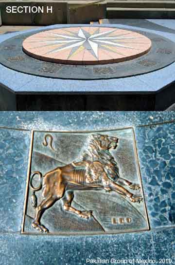
Section H includes a compass in the right side of the monument and it makes a pleasing pattern viewed from above with the 12 signs of the Zodiac. I have included the Leo sign because it represents a special meaning for my birth and significant events which will happen in the Maya astronomical calculations of the Star Chart in 2012, such as the culmination of the Maya Long Count calendar on December 21, 2012.
And in this section, you can appreciate the esoteric genius of the designer. In Hansen’s precession design, I found the Zodiac as a lost symbol, the common thread between the Greek/Egyptian astrological ages and the Mayan great ages. In mathematical terms, Hansen tells me of the precession of five Mayan ages (as Mayas determined an age to be 5,125 years). This number multiplied by 5 produces the number of years of a full precession equals to 25,625 years. A great astrological cycle which includes all the twelve zodiac signs lasts roughly 25,920 years.
As Hansen explained, “Instead of measuring 12 earthly hours, the dials measures a Platonic Year or Great Year, made up of 25.694.8 of our ordinary years. We cannot be sure of the exact length of the Platonic Year, because the civilized story of man, and hence, astronomy, is at the most only 10,000 years old; but we feel certain that it may not vary from the above mean time by more than 281.2 of our ordinary years”.
ASTRONOMICAL SIGNIFICANCE OF USA 2012
Although Hansen never mentioned a Maya involvement in his design, other industrial designers and architects of that era were heavily influenced by ancient cultures in the Deco Art style. One architect that comes to my mind was the most known American architect Frank Lloyd Wright, who used pre-constructed cement blocks to build the Ennis Brown House with Mayan Deco features.
Therefore, it is obvious, as in the case of Chichen Itza, there is a Maya astronomical concept that describes the Earth precession in his Star Chart as we will see in 2012. More, he based his initial calculations. marked in the terrazzo, including the position of Pharaoh Khafre’s pyramid five thousands years ago (2700 B.C.) when Thuban (Alpha Draconis) was the pole star of the ancient Egyptians, the Biblical star of Egypt, as well as the incarnation of the historical Jesus, marking the beginning of the Christian Era, as indicated midway between the location of Thuban and Polaris.
By walking to the rear of the base, upon which rest the winged figures, one can locate Vega, the pole star that will replace Polaris, thousands of years in the future.
For the amateur astronomer, below you will find the astronomical precession data of Hansen’s Star Chart for the Year 2012 with the general elements explained before in Hoover Dam.
|
ASTRONOMICAL PRECESSION CALCULATIONS OF STAR CHART |
|
|
For Friday, December 21, 2012 (leap-year) – 11:11 UT |
|
|
Greenwich Mean Sidereal Time |
17 12 41.833 |
|
Mean Obliquity of Ecliptic |
23 26 15.375 |
| Nutation Elements (“) | deltaPsi = 14.046 deltaEps = -5.884 |
|
Precession Elements from J2000 |
zeta0 = 0 4 59.164 |
An interesting Hansen prediction of the Star Chart, open to reflection in 2012 says: “When, in the course of time the composition of our world and those other worlds in space shall be more fully known, record it here for future men to see … and having seen, to speculate, investigate and carry on the search”.
CONCLUSIONS
If I were to apply Maya concepts to Hansen’s Star Chart, it is my personal opinion that the designer built a Universal Clock next to a source of natural energy, the Colorado River, which Native Americans and myself consider as the Great River Serpent that gives life to Earth. In fact, I was pleasantly surprised that the Colorado River Indian Tribes form now a geo-political unit, which consists of four distinct Tribes – the Mohave, Chemehuevi, Hopi and Navajo. There are currently about 3,500 active Tribal members.
It is my hope that the astronomical calculations in the Star Chart in 2012 will bring more environmental sustainability to the Colorado River regions and social justice to our Native Americans, one of the blood-related branches of our Maya ancestors. It is the true Law of the River.
Lord Pakal Ahau.
June Equinox Solstice
Pakalian Group of Mexico. (June 21, 2010).
NOTES FROM THE EDITOR: Next, we invite you to look at our post of the 2012 Hopi Design of the Hoover Dam in Nevada/Arizona. If you’re a 2012 Maya fan you might want to collect this unique shirt with its centrifugal theme. A truly 2012 feature of the our Mayan calendar. Thanks for your visit.

Find your thrills and cool stuff.
Click this red link to go to our central store.
 If you access one of our pages in the blog, click the icon to go to main page.

Saturday, December 24, 2011 at 6:35 am
what an interesting research and info for me – a lonesome stranger looking for truth on this wonderfull planet !!! thx